
Cherry Hill Neighbors by Parcel
For the block around a Cherry Hill address, start with land rather than names. County Mapper can display the target parcel and the nearby parcels that touch it. PublicAccessNow then supplies the parcel’s assessment record, including the owner and separate mailing and situs fields where maintained. Eagle adds the recorded deed trail, while the association layer can identify a community boundary and a public contact. These sources describe parcels, recorded transactions, and voluntary community information. None is a complete roster of people at every nearby address.
| Source | What It Shows About a Block | Access |
|---|---|---|
| County Mapper adjacent parcels | Parcel geometry, GPIN, address, and selectable public layers | Free browser map with identify, click, buffer, and select tools |
| PublicAccessNow | Owner and assessment record for a selected parcel | Free address or GPIN search; no public name search |
| Eagle Recorder | Recorded deeds, plats, parties, dates, and legal descriptions | Free index; paid online image or courthouse-terminal route |
| Association GIS layer | Association boundary, type, voluntary contact, and management data where supplied | County Mapper layer; entries can be outdated |
| Virginia voter access | Individual registration status and district information | Identity-controlled portal or separate qualifying list request |
| RELIC directories | Historical occupant or subscriber leads for a dated edition | On-site books, microfilm, microfiche, and library databases |
Ownership and occupancy must stay separate. An assessor card can show a recorded owner and tax mailing address, but the mailing address may be elsewhere. A deed confirms a recorded transaction, not who is present today. A directory entry is time-stamped and may list only a head of household or subscriber. That careful language is especially important when identifying Cherry Hill neighbors from public records.
Cherry Hill Parcel Map Tools
Prince William County Mapper is the practical starting point for a tight radius around one address. It accepts GPIN, street number and street name, map selection, intersection, or coordinates. The viewer also exposes street type and unit fields, a building-unit search control, layer queries, and a buffer distance with unit. At detailed scale, parcel information can be enabled for address and GPIN pop-ups. The help materials say those parcel pop-ups become available at about 1:4,800 or below, and the map itself is not a legal description.
The County Mapper overview below describes the official parcel and address viewer. Select Land Records or Land Development when that layer is useful, and use Identify only on visible layers. Public Services, Service Areas, Environment, Public Utilities, contours, and aerial imagery offer geographic context but do not turn a parcel boundary into proof of a resident.
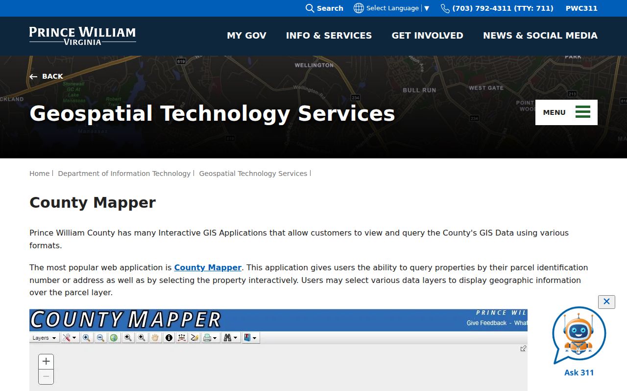
The map controls give a repeatable way to examine immediate Cherry Hill neighbors without claiming that every nearby person is publicly identified. Clear search graphics before starting a new address so a prior selection does not get mixed into the next block.
For a building, zoning, subdivision, or plan question that does not appear online, the Development Services Records Center is the county fallback. It holds plans, permits, subdivision and land-development material. No complete public address-indexed permit database was located, so request a specific address, project, date range, or GPIN through the Records Center or the county records process.
Mapping Cherry Hill Neighbor Parcels
The adjacent-parcel method keeps a neighbor search tied to a physical block. Locate the target parcel, zoom to a detailed scale, and click the polygons that touch it. For an irregular block, County Mapper’s Buffer Distance, Buffer Unit, Return Address, and Start Buffer controls can return a broader set of parcel features. Record only the data the map and parcel card actually display, then open Eagle only when a recorded ownership or plat question needs more detail.
- Search the target Cherry Hill address or GPIN in County Mapper, turn on parcel information, and use Identify to confirm the target polygon.
- Click the touching polygons, or use Buffer and Select Parcel Features when the practical block is not a simple row of lots. Note each visible GPIN and situs address.
- Open each GPIN in PublicAccessNow. Read the recorded owner, tax mailing address, legal description, assessment, and sale history as parcel facts, not as a household claim.
- When the title trail matters, search the owner and recording context in Eagle for a deed or plat. Use the legal description and instrument reference to avoid mixing similar addresses.
- For the wider chain along a named road, use the Cherry Hill Street Directory rather than extending this close-block method across an entire corridor.
The PublicAccessNow GPIN search shown below is the bridge from a map selection to the parcel record. A GPIN is the stable land key linking the map, assessment card, and deed work. It identifies land, not all people associated with a dwelling.
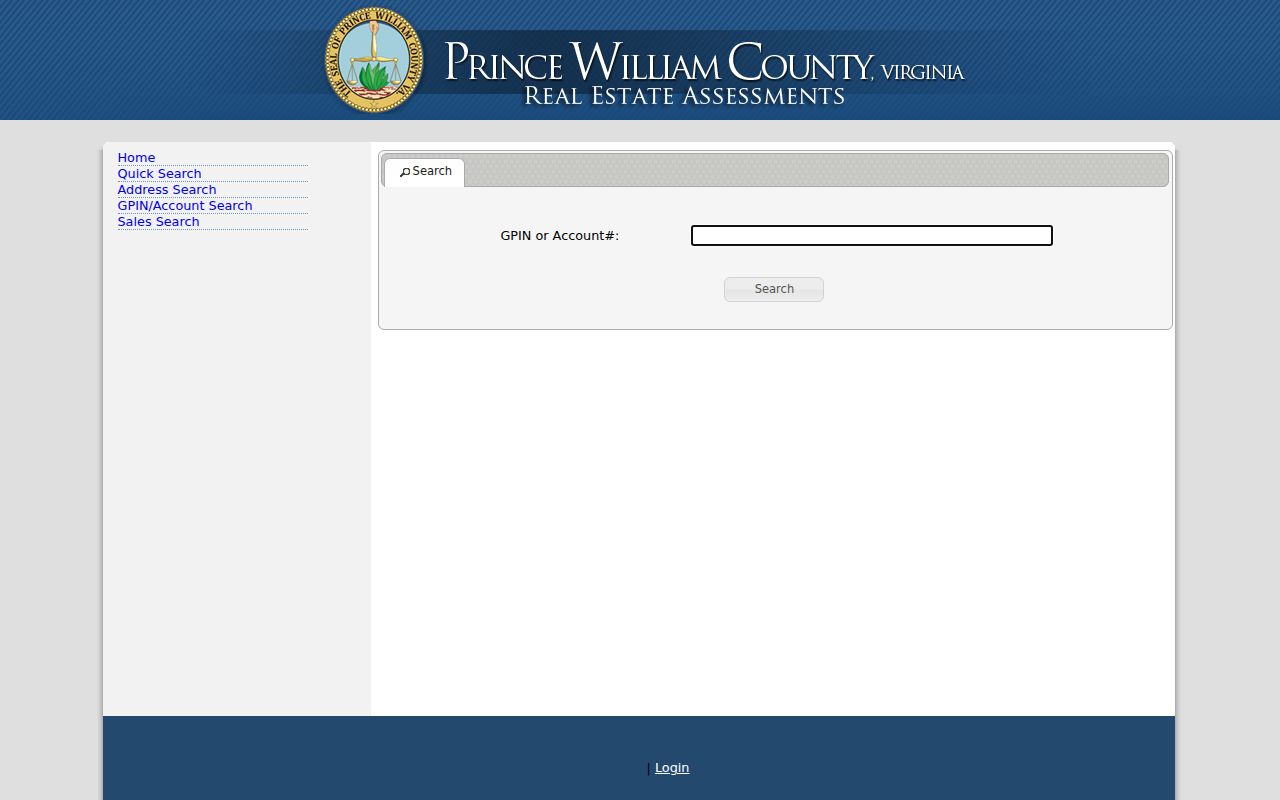
The GPIN form shows why a parcel number is often more dependable than a street label. Prince William formats it as xxxx-xx-xxxx, while account or RPC values require six characters and may need leading zeroes.
Note: The County Mapper boundary and parcel details are useful research aids, not a substitute for the recorded legal description.
Cherry Hill Association Contacts
The community layer is narrower than a member list. Prince William County Neighborhood Services maintains a verified but voluntary COA and HOA database, while the County Mapper Property Owner Associations layer supplies geographic context. The layer can include an association name, boundary, type, voluntary website, phone, email, management-company fields, mailing contact, zoning case, and last-edited information. An association must update its own voluntary details, so confirm any contact before relying on it.
| Association resource | Useful public information | How to verify |
|---|---|---|
| County Mapper Property Owner Associations layer | Boundary, association type, voluntary contact, and management metadata where supplied | Match the selected Cherry Hill parcel to the displayed boundary, then confirm the contact |
| Neighborhood Services COA/HOA database | Verified voluntary association listing and county guidance | Check the current county listing or contact Neighborhood Services |
| Cherry Hill/Potomac Shores and Cherry Hill Crossing context | Development and association clues, including the Cherry Hill Crossing condominium subdivision record | Use the county association layer, plat records, and Neighborhood Services; no complete public member roster was located |
The Prince William County association database is pictured here. It is the appropriate lead for a public contact or community boundary, not for requesting private membership or resident information.
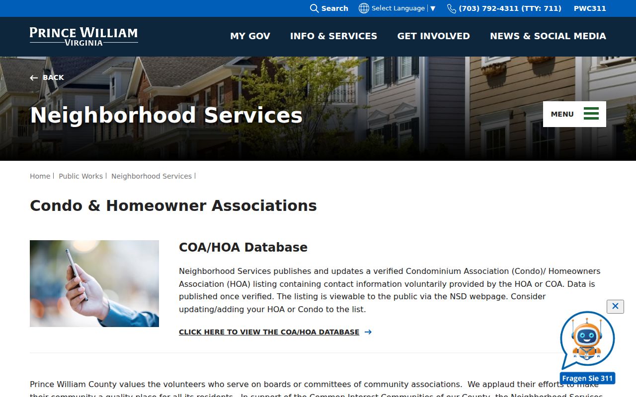
The database connects public community information to the proper county guidance. Neighborhood Services is located at 5 County Complex Court, Suite 280, and lists (703) 792-7018 as its umbrella contact. The county does not take over association governance or maintenance.
Cherry Hill Voter Record Rules
Virginia’s Citizen Portal is for an individual’s registration status and election information, not a Cherry Hill neighbor browser. It requires a name, date of birth, the last four SSN digits, locality, and certification. The returned information can include status, polling place, districts, absentee information, and voting history for the identified user. A street-wide list cannot be made by entering adjacent addresses in the portal.
A full voter product follows a separate Department of Elections request form. Its filters can cover locality, district, election, and related categories, but the requester must fit a listed category and sign the use and responsibility terms. The form covers products such as registered voter, those-who-voted, newly registered, and vote-history lists. It is not a casual block lookup. For individual-status help, use the state portal or the Prince William Office of Elections at 9250 Lee Avenue, Suite 1, Manassas.
Virginia voter records do not show ballot choices. A registration result also does not establish that every person in a household is on the record, still resides at an address, or is publicly available for contact. Protected voters and Address Confidentiality Program participants require particular care.
Official Cherry Hill Neighbor Tools
Official records and private compiled neighbor tools answer different questions. County sources identify their custodian, geographic key, dates, and access limits. A private compilation may blend old directories, public filings, marketing data, or user-submitted material. That can be useful as a prompt for further research, but a result should be tested against the public record that actually supports it. The comparison below keeps the focus on source quality rather than names collected by a commercial category.
| Record path | Best use around a block | Limit to remember |
|---|---|---|
| County Mapper and PublicAccessNow | Confirm the parcel, GPIN, assessment context, and recorded owner field | Owner and mailing fields are not a household roster |
| Eagle Recorder and plats | Confirm a recorded transfer, legal description, subdivision, or easement | Recorded ownership does not establish current occupancy |
| Association and civic contacts | Find a boundary, meeting contact, or public management point | Voluntary data can be stale and private membership is not presumed public |
| Private compiled tools | Generate a lead to test with a custodian | Stale entries and same-name merges can occur, with unclear dates or sources |
The County Mapper association layer is especially useful because it connects a visible parcel boundary to public association metadata where an organization supplied it. Verify names, management details, and dates through Neighborhood Services or the association’s own public contact before acting on them.
Note: A private compiled result needs a date and a custodian check before it is treated as a current block fact.
Cherry Hill Historical Block Records
Modern maps can be paired with a dated historical layer when the question concerns past neighbors rather than the present block. RELIC at Central Library has regional directories, county directories, telephone books, maps, newspapers, cemetery and church material, yearbooks, obituary indexes, and microfilmed county records. A reverse or criss-cross directory, when present in a particular edition, organizes entries by address or phone and can supply a time-stamped occupant or subscriber lead.
Cherry Hill may not appear under its modern CDP label in older materials. Search historic references such as Neabsco, Dumfries, adjacent villages, rural-route headings, and road names. The 1992 Historical Map index at RELIC can connect alternate place names by grid or quadrant. For a historic owner, follow the deed and legal description separately. For a historical household, compare a directory edition to census, obituary, probate, church, cemetery, or newspaper evidence.
RELIC’s paper, microfilm, and staff-assisted routes matter because many of its relevant directory runs are not digitized. County-wide directories are documented for 2001 and 2007 through 2020, while regional and telephone collections reach earlier periods with gaps. A missing entry can reflect a skipped volume, rural exclusion, non-subscription, or a different heading, not proof that a person was absent.
Cherry Hill Neighbors Across ZIPs
Cherry Hill’s Census geography is associated with two ZIP Code Tabulation Areas, 22026 and 22191. Census counted 23,683 people in the CDP in 2020, compared with 16,000 in 2010, but those figures describe a statistical place rather than an incorporated government or a list of residents. A nearby address can use Dumfries or Woodbridge as its postal city while remaining in Prince William County and within or adjacent to the Cherry Hill CDP context. That difference is a records issue: the postal address is helpful for delivery, while the GPIN and legal description tie the parcel to county records.
Use the USPS ZIP Code Lookup to verify a particular address. Neither PublicAccessNow nor County Mapper showed a visible ZIP-wide search field during inspection. For a road crossing the two areas, verify each address through USPS, then use the county map and GPIN for parcel work. A postal boundary should never stand in for a neighborhood boundary or a list of Cherry Hill neighbors.
Note: ZIP, Census place, county jurisdiction, and parcel boundaries are separate maps that can overlap without matching.
Cherry Hill Neighbor Lookup Limits
Adjacent parcels show land records, not everyone who lives nearby. Renters, roommates, children, guests, utility customers, delivery recipients, and protected residents may never appear in the sources described here. Virginia’s Address Confidentiality Program protects the actual addresses and program records of eligible participants through a substitute-address system. DMV personal information is also restricted. Do not try to fill a gap by reconstructing protected information from maps, voter data, or other records.
Lawful use. Use Cherry Hill neighbor records for lawful personal, civic, safety, or community-contact purposes. Do not watch, threaten, harass, intimidate, or attempt to expose another person.
Virginia’s stalking and computer-harassment laws apply even when the first fact came from a public source. If a parcel, association, or court record is wrong, contact the custodian that holds it. Keep descriptions precise, such as recorded owner, directory entry, or permit applicant, rather than claiming to know every household member on a block.